 Canada lies in North America and is best known for its beautiful nature and the great national parcs, its gooses and mooses. The capital of this country is Ottawa which is a big city. There are more cities on Canada like Ottawa, for example there are the cities Vancouver, Montreal, Quebec and Calgary. This beautiful country lies between the United States of America and Greenland. A lot of people ask the question “how big is Canada?”. The answer to this question is that it’s next to Russia the biggest country in the world, so it’s really big 🙂
Canada facts on a row
- Capital of Canada: Ottawa
- On which continent: North America
- Flag: Red and White with a Maple Leaf in the middle
- Neigbours: USA and Greenland
- Known for: Rockey Mountains, Marshall Islands, National Parcs
- Other know abouts: You have to spell/write it with a “C”, not as Kanada
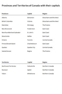
Regions of Canada with the Provinces and Territories
Another frequently asked question is “is Canada part of the US?”. Well, we can be very clear about that, because the answer to that is “No”. You can devide this country in regions, each region has their own provinces and/or territories. Below we mention these regions with the associated provinces.
- Northern Canada, with the 3 territories knowing Yukon, Northwest Territories and Nunavut
- Mountains and the West with the provinces British Columbia and Alberta
- The Prairies with the provinces Saskatchewan and Manitoba
- Central Canada with the provinces Ontario and Quebec
- East Coast with the provinces Newfoundland & Labrador, New Brunswick, Nova Scotia and Prince Edward Island
Canada coloring pages
We offer some great coloring pages for you. We have some of the Canadian goose, some mooses and of course with “Happy Canada Day” which is in Canada on the first of July. There are also some flags and maps to color in yourself.
Map and Learning Tools
When you have to learn about the provinces and territories, we have a Canadian map and a great learning tool for you. Within the learning tool you’ll find the regions, provinces and territories with their capitals. When you have to learn about it, just print it and hang it somewhere you will see it often. For example on the toilet, the best place for learning tools. Of course you can also print the map of Canada to use it as a learning tool. Good luck!
World learning tools
Countries of the continent North America
All continents of the world with their countries


